This practice note has been prepared as an information source to assist with the interpretation and application of the Coastal environment overlay code. It focuses only on elements of storm tide inundation.
It is a supporting document that seeks to build further understanding and capacity around the policy position of the Coastal environment overlay. It has been designed to adequately manage assessment of development, particularly around risk to development in coastal hazard areas.
“The state’s interest in natural hazards, risk and resilience seeks to ensure natural hazards are properly considered”, including “avoiding or mitigating the risks associated with natural hazards to an acceptable or tolerable level, increasing community resilience and decreasing the burden for emergency management.”
“Exposure of communities to natural hazards such as bushfire, landslide, flood and coastal risks such as storm surge and sea level rise, will be avoided wherever possible.”
There are several key aspects of the code which reflect the policy position of the strategic framework. The most important aspects of the code are:
The following information is provided on the basis of the land being in an urban or rural residential area only. In all other cases the policy position is: "Development does not expand into coastal hazard areas beyond areas zoned for urban and rural residential purposes".
In applying the coastal protection overlay code, the following specific provision has been detailed as it is the most pivotal for assessment purposes in urban or rural residential areas:
PO7 Development is located outside high or medium storm tide inundation areas and erosion areas from sea level rise identified on overlay maps OM-3.1 and OM-03.2 unless it either:
Editor’s note: The inner city area shown on Figure 8.1 - Coastal hazard areas: storm tide inundation areas is intended to be defended from storm surge risk by public works.
In applying the above outcome, one of the following provisions are provided:
Development can occur without resulting in an increase in the intensity of development. For this purpose, increase in intensity means reusing, one or more additional lots or new development that, for the purposes of the Planning Act 2016, is a material change of use or a Reconfiguration of a Lot. Development may proceed to Provision B and C. Note, that under Provision C, this gives an applicant the ability to reduce risk.
Development is located in the Inner city areas, as shown on the Coastal environment overlay maps. This area may ultimately be defended with coastal defence infrastructure and therefore, development can be protected. For development applications in this area, it should be demonstrated that:
Development avoids any increase in risk to people or property from coastal hazard impacts (including impacts on the development’s ongoing operation). In applying this provision, the following is provided:
I. Applicants are able to demonstrate how the development avoids increase in risk if they are not able to meet Provision A or B.
II. Applicants may demonstrate an increase in the intensity of development as follows:
III. In determining if a development has reduced risk to persons and property, the following two tables (below – adapted from CHAS) should be used. If the development is able to satisfy the below table requirements to an acceptable or tolerable level, then development may be supported.
IV. Applicants should clearly demonstrate that any increase in risk is tolerable or acceptable in accordance with the tables below, including how the proposed mitigation measures will achieve this in line with the requirements of point II above.
| Permanent Sea Level | Residential property | Commercial/industrial property | Open space/rural – other |
|---|---|---|---|
| > 5% of block inundated | Unacceptable risk | Unacceptable risk | Tolerable risk |
| < 5% of block inundated | Tolerable risk | Unacceptable risk | Acceptable risk |
Source: Townsville City Council Coastal Hazard Adaption Strategy (CHAS)
| Event Range | Residential buildings – above floor flooding | Commercial/industrial buildings – above floor flooding | Open space/rural – other |
|---|---|---|---|
| 1% AEP | Unacceptable risk | Unacceptable risk | Acceptable risk |
Source: Townsville City Council Coastal Hazard Adaption Strategy (CHAS)
Notes: Table 2 (above) shows the level of risk for categories of development where the 1% storm tide AEP can inundate above floors for residential, commercial/industrial and open space/rural/other. In this circumstance, the risk is considered unacceptable and development would not be supported. If development can demonstrated that the 1% AEP storm tide event does not inundate over floors, then the risk may be either tolerable or acceptable. In this circumstance, development may be supported.
The defined storm tide event level is the 1% annual exceedance probability (AEP) storm tide event with an allowance of 0.8m sea level rise to 2100 and an increase in maximum cyclone intensity of 10% relative to present day conditions. For this planning scheme, this level is RL4.5m (AHD), within 100m of the coastline (open coastal line) or RL3.9m AHD in other areas.
The defined storm tide event level is higher within 100m of the open coast line to allow for wave set-up. The defined storm tide event level includes projected permanent sea level inundation which is land at or below RL3.05m AHD.
Land mapped by the Coastal protection overlay and located at or below 3.05m AHD may be subject to permanent sea level inundation in addition to the potential for storm tide inundation.
Yes. For the purposes of the Townsville City Plan, a Class 10 Structure or Building is not regulated by the Coastal environment overlay and remains accepted development. Construction of a Class 10 Structure will still require a Building Works Approval.
No. Houses are accepted development subject to requirements in the Coastal environment overlay which means you need only comply with accepted development subject to requirements code provisions and no application is required unless you cannot comply with the code provisions. If your property is stated as either code or impact in the zone table of assessment (Part 5.5) then that level of assessment will prevail and you will require approval.
The Flood hazard and Coastal environment overlay operate independently, but together, may impact on the development response. For example, if the Flood hazard overlay requires a higher standard of immunity in a development than the Coastal environment overlay (or vice versa), then the higher level prevails in all cases.
I want to subdivide my land and it is affected by the Coastal environment overlay – high hazard storm tide.
A subdivision of land may still occur in the high hazard storm tide inundation where the risk from permanent sea-level inundation is determined to be either tolerable or acceptable, as per Table 1 of this practice note. Land at or below RL3.05m AHD is considered at risk from permanent sea level inundation and is not supported.
This may not always be the case as the proposed development must meet all the requirements of the Townsville City Plan.
For example, a unit development may meet the Coastal environment overlay provisions but be out of character for an area (in accordance with the zone intent) and detrimentally impact on the amenity of the area.
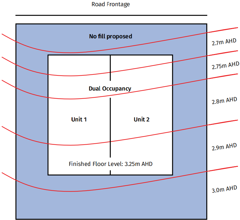
Unsuitable Proposal that does not meet overlay outcomes:

Explanatory Note: Example 1 does not represent an acceptable or tolerable outcome for managing risk. The acceptable outcomes of the Overlay seeks to ensure that habitable floors are above the 1% AEP storm tide event (3.9m AHD) which will achieve an acceptable/tolerable level of risk. Further, the lot is below the estimated permanent sea-level rise value to the year 2100 of 3.05m AHD which represents an unacceptable risk.
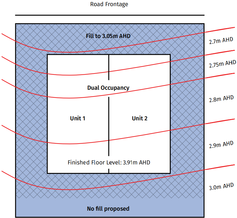
Suitable Proposal that does meet overlay outcomes:

Explanatory Note: Example 2 represents an acceptable/tolerable outcome of managing risk. The example demonstrates that the proposed dwelling is locating habitable floors (not slab on ground) above the 1% AEP event level which represents an acceptable or tolerable risk. Further, the lot level has been filled to 3.05m AHD which mitigates the risk of the estimated permanent sea-level rise value to the year 2100 (to less than 5% of the lot in above example) and represents a tolerable level of risk. The placement of fill will need to consider the Flood overlay and local stormwater measures (drainage), including, being located outside of the erosion prone area.