A planning scheme (referred to as Townsville City Plan) is a legal document prepared by council under the Planning Act 2016. A planning scheme guides and regulates the development of land. All new planning schemes in Queensland contain the same zone types – making it easier for users in multiple local government areas. The Townsville City Plan is made up of two key elements: a written component and maps.
The Townsville City Plan was developed under the Sustainable Planning Act 2009 (superseded) and has been aligned to the Planning Act 2016. The Townsville City Plan is made up of the following components:
Sets the policy direction and forms the basis for ensuring appropriate development occurs within the city for the life of the Townsville City Plan.
Integrates land use planning and infrastructure planning, ensuring that trunk infrastructure is planned and provided in an efficient and orderly manner.
Identifies if a development application is necessary, the category of development and assessment, the codes and other provisions the development may be assessed against.
Zones designate land for a particular use (e.g. residential, industrial, rural). All land in Townsville is included in a zone. Precincts may be identified for a part of a zone. A precinct provides further detail for a specific area within a zone.
Identifies areas that have unique characteristics that require further planning consideration when a development is proposed. These characteristics may relate to natural hazards such as bushfire, flooding or landslides, contain a value such as biodiversity or cultural heritage, or a constraint such as proximity to an airport, quarry or major water resource (e.g. Ross Dam).
Relates to specific types of development such as reconfiguration of a lot applications.
Provide information such as mapping, definitions, planning scheme policies, land for community infrastructure and listing of places of cultural heritage value.
The Townsville City Plan regulates land use activities defined as ‘development’ under the Planning Act 2016. The Planning Act 2016 empowers local governments to create planning schemes for application over a local government area to appropriately regulate development, including:
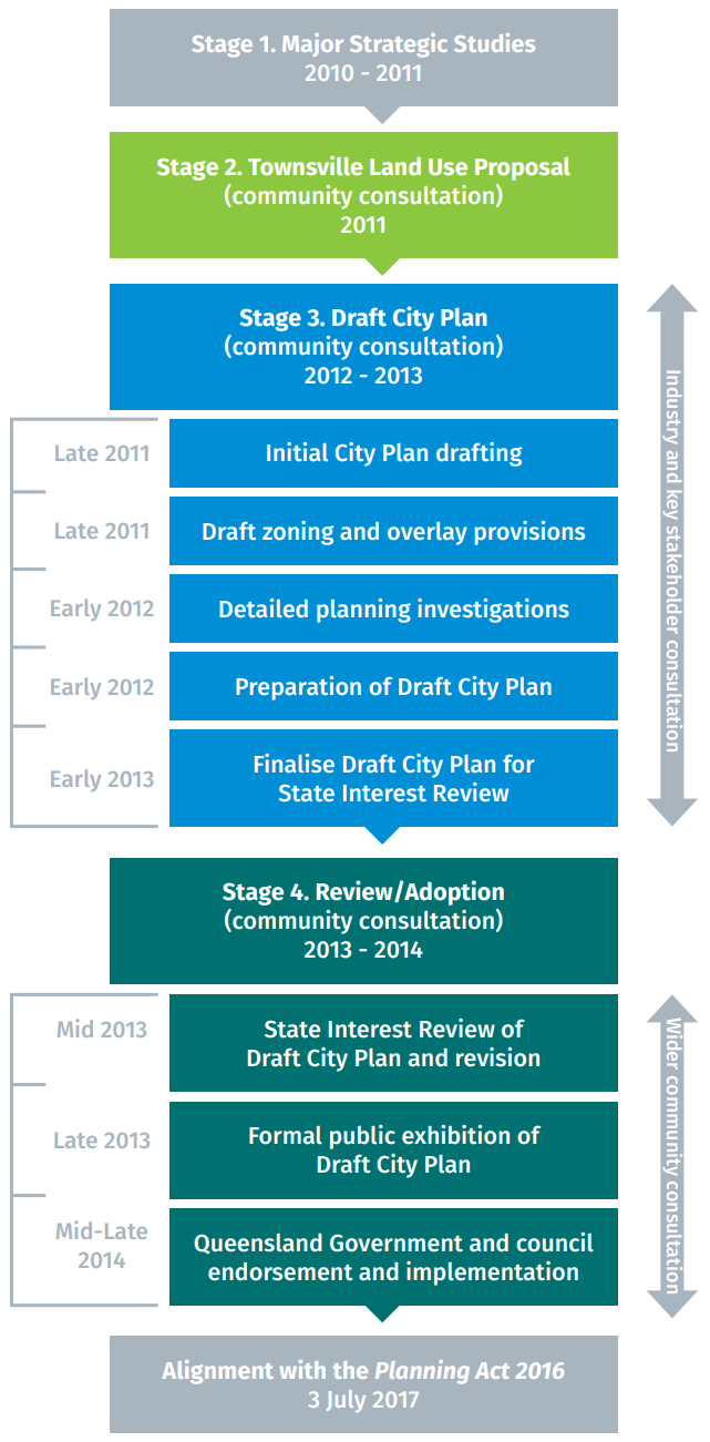
Extensive preparation and supporting investigations were undertaken in the development of the Townsville City Plan.
Comprehensive consultation with the community was conducted to ensure that the Townsville City Plan reflects the community’s vision and priorities (as per the Townsville Community Plan) for the city.
The first phase of community consultation for the Townsville City Plan aligned with the Townsville Community Plan community engagement program, Speak Up Townsville.
The development of the Community Plan supported one of council’s major supporting studies, the Townsville Land Use Proposal (TLUP). Council commenced this process in 2010.
The TLUP set out the preferred settlement pattern for the city and the proposed planning policy directions to be implemented via the Townsville City Plan.
Throughout the development of the TLUP, Townsville City Council was committed to proactive consultation with the State Government.
The supporting studies, Townsville’s Community Plan, the Townsville Land Use Proposal and various community engagement workshops have collectively informed the development of the Townsville City Plan.
